
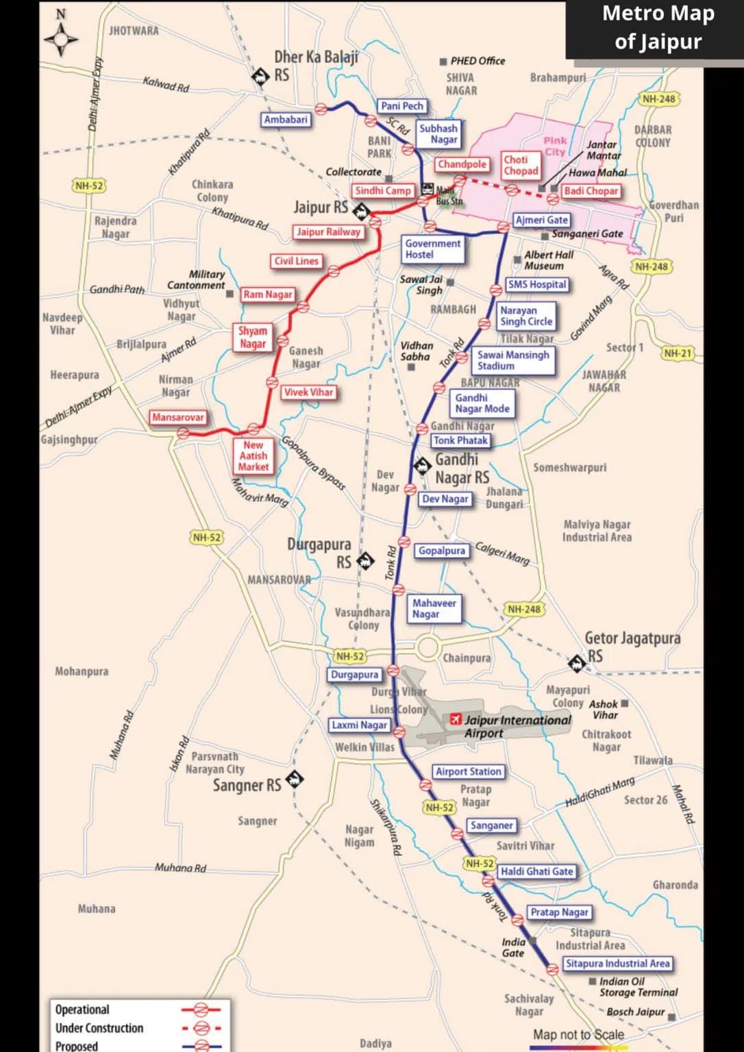
Jaipur Metro Route Map 2026 with All Stations
Full route map of Jaipur Metro Pink Line with every station listed, interchange points, distances between stations, and surrounding landmarks for each stop.
Total Stations
11
Line Length
12 km
End-to-End Time
~25 minutes
Busiest Station
Civil Lines
Tourist Hub Station
Badi Chaupar
Max Fare
₹30
The Jaipur Metro route map looks simple on paper. One line, 11 stations, 12 kilometres. But each station connects to a different pocket of the city, and knowing what surrounds each stop turns a basic transit ride into a navigation shortcut across Jaipur. This guide walks through every station on the Pink Line from west to east, with the practical details travelers actually need.
Pink Line Overview
The Pink Line is Jaipur Metro's only operational corridor as of 2026. It runs 12 km from Mansarovar in the west to Chandpole in the east, passing through 11 stations. The entire end-to-end journey takes approximately 25 minutes. Trains operate between 5:30 AM and 10:30 PM daily, with frequencies of 5 to 7 minutes during peak hours and 10 to 12 minutes off-peak.
The line was built in two phases. Phase 1A (Mansarovar to Chandpole via the elevated and underground sections) opened for public service and has been operational since. The corridor passes through residential suburbs, the commercial heart of the city, and ends at the edge of the historic walled city.
Every Station on the Pink Line
1. Mansarovar (Western Terminus)
The starting point of the Pink Line sits in one of Jaipur's largest residential colonies. Mansarovar station has dedicated car and two-wheeler parking, making it a popular park-and-ride option for commuters travelling into the city centre. The station is elevated and offers views across the surrounding neighbourhood. Nearby landmarks include Mansarovar Plaza, Sector 7 market, and Shipra Path commercial area. Auto-rickshaws outside the station connect to Vaishali Nagar, Pratap Nagar, and the Ajmer Road corridor.
2. New Atish Market
A mid-line elevated station serving the New Atish Market commercial area. This stop is useful for accessing wholesale electronics and hardware shops along the main road. The surrounding area is primarily commercial during the day and quieter in the evening. Auto stands outside connect to Durgapura and Malviya Nagar.
3. Vivek Vihar
Serving the Vivek Vihar residential area, this station sees steady commuter traffic during morning and evening peaks. Schools and coaching institutes in the vicinity generate student ridership. The station is elevated with standard amenities including drinking water and basic seating.
4. Shyam Nagar
Shyam Nagar station sits at the intersection of residential neighbourhoods and small commercial markets. The feeder bus FB-06 connects from here to surrounding colonies including Hasanpura. This is a mid-tier station with standard facilities but no ATM or food kiosk on premises.
5. Ram Nagar
Ram Nagar serves a dense residential area and is one of the quieter stations on the line. The surrounding neighbourhood has local markets, temples, and residential lanes. The station provides basic transit connectivity rather than serving as a destination in itself.
6. Civil Lines (Busiest Station)
Civil Lines is the busiest station in the entire Jaipur Metro network and the operational hub of the system. Located adjacent to the Sindhi Camp inter-state bus terminal, it handles the highest daily passenger volume. The station has the most comprehensive amenities: multiple ATMs, a food court area, an air-conditioned waiting lounge, the Central Lost and Found desk, and the largest parking facility on the network.
Key connections from Civil Lines include the FB-02 feeder bus to SMS Hospital, walking distance to Rajasthan University, and auto-rickshaw access to most parts of central Jaipur. The Sindhi Camp bus stand provides intercity buses to Delhi, Agra, Udaipur, and Jodhpur.
7. Sindhi Camp
Located near the main bus terminal area, Sindhi Camp station is the second major transit interchange on the Pink Line. The station is within walking distance of the Government Hostel area and several budget hotels, making it relevant for travellers arriving by bus. Auto stands outside offer connections to the railway station area.
8. Chandpole (Eastern Terminus)
Chandpole is the eastern end of the Pink Line and the gateway to Jaipur's historic walled city. The station is underground, built beneath one of the busiest intersections in the old city area. From Chandpole, the walled city's markets, havelis, and temples spread out in every direction.
Key access points from Chandpole include Johari Bazaar (jewelry market, 1.2 km walk or FB-03 feeder bus), Tripolia Bazaar (textiles and crafts), and the western gates of the walled city. For tourists, this is the primary metro station for exploring the old city on foot.
9. Chhoti Chaupar
Named after the small square (chaupar) intersection, this underground station puts you right inside the walled city. The surrounding area is packed with local shops, sweet shops, and textile traders. Walking north from here leads toward Nahargarh Fort Road.
10. Badi Chaupar
Badi Chaupar (the large square) is the tourist epicentre of the metro network. This underground station is the closest metro stop to Hawa Mahal, which is approximately 1.5 km away via the FB-04 feeder bus or a 20-minute walk through the walled city. The station also provides access to City Palace, Jantar Mantar, and the densest concentration of heritage shops and restaurants in Jaipur.
11. Pink Line Extension Stations
The operational network also includes stations along the southern spur serving the Sitapura Industrial Area, connecting the IT corridor and manufacturing zones to the main city network. These stations primarily serve office commuters during weekdays.
Distances Between Key Stations
Understanding inter-station distances helps estimate travel time and fare:
- Mansarovar to Civil Lines: approximately 6 km, 12 minutes, fare ₹20
- Civil Lines to Chandpole: approximately 3 km, 8 minutes, fare ₹15
- Mansarovar to Chandpole (full line): 12 km, 25 minutes, fare ₹30
- Badi Chaupar to Civil Lines: approximately 4 km, 10 minutes, fare ₹20
Reading the Route Map at the Station
Every station platform has a large colour-coded route map mounted on the wall. The Pink Line is marked in pink. Each station is represented by a circle with its name in Hindi and English. The direction arrows show which platform to use: towards Mansarovar (westbound) or towards Chandpole (eastbound). Inside the train, an identical map with LED indicators shows your current position and upcoming stations.
Planned Expansions Beyond the Pink Line
The Phase 2 Orange Line will add approximately 41 km and 36 new stations, including a dedicated airport connection. This will transform the current single-line network into a proper metro grid. Until then, the Pink Line remains the only operational corridor, and feeder buses plus auto-rickshaws fill the last-mile gaps.
Key Highlights
- 111 stations across 12 km from Mansarovar (west) to Chandpole (east)
- 2Full line journey takes 25 minutes end to end
- 3Civil Lines is the busiest station with maximum amenities
- 4Chandpole and Badi Chaupar are the main tourist access stations
- 5Trains run 5:30 AM to 10:30 PM with 5 to 7 minute peak frequency
Practical Tips
- →Download or photograph the route map at the first station you visit for offline reference
- →Civil Lines is the best station for transit connections to buses, hospitals, and intercity travel
- →Badi Chaupar is your stop for Hawa Mahal, City Palace, and Jantar Mantar access
- →Mansarovar has the best parking if you want to park and ride into the city
- →The underground stations (Chandpole, Chhoti Chaupar, Badi Chaupar) are cooler in summer heat
Frequently Asked Questions
Plan your Jaipur Metro journey
Use our free tools to calculate fares, check timings, find stations, and discover what to see near each stop.